A new LION is on the way — we're bringing every tool into one dashboard, so some pages will change soon. Thanks for bearing with us as we upgrade.
LION · Local Integrity Oversight Network
What the Public Record Shows: McKinney Site-Plan Case 25-0081SP
A primary-source brief on the McKinney Islamic Association site plan — organized by issue.
Every claim links to the City's own record.
Case 25-0081SP (SITE2025-0081)Final vote City Council · Aug 4, 2026 · consentSite Virginia Pkwy & Crutcher Crossing (~5.57 ac)Updated 2026-07-31
What this is. LION examines whether the City applied its own rules. It makes no claim about any
religious community and no accusation against the applicant; where the record is silent, it says so. Not legal advice.
Every citation links to its public source, and every original is preserved unchanged in LION's archive.
Updated explainer coming
We’re rebuilding the short explainer from the corrected record. In the meantime, the full,
sourced brief is right here — every finding below links to the City’s own documents.
Update & correction · 2026-07-30
Readers checked our math — and made this stronger.
An earlier version of this brief read the plan’s building numbers as footprints and said the two-story buildings
roughly doubled the 15,000-sq-ft cap. Two readers flagged it, and they were right: those numbers are gross floor
areas, so the masjid sits at the cap, not over it. We corrected it — with thanks. Then we pulled the City’s
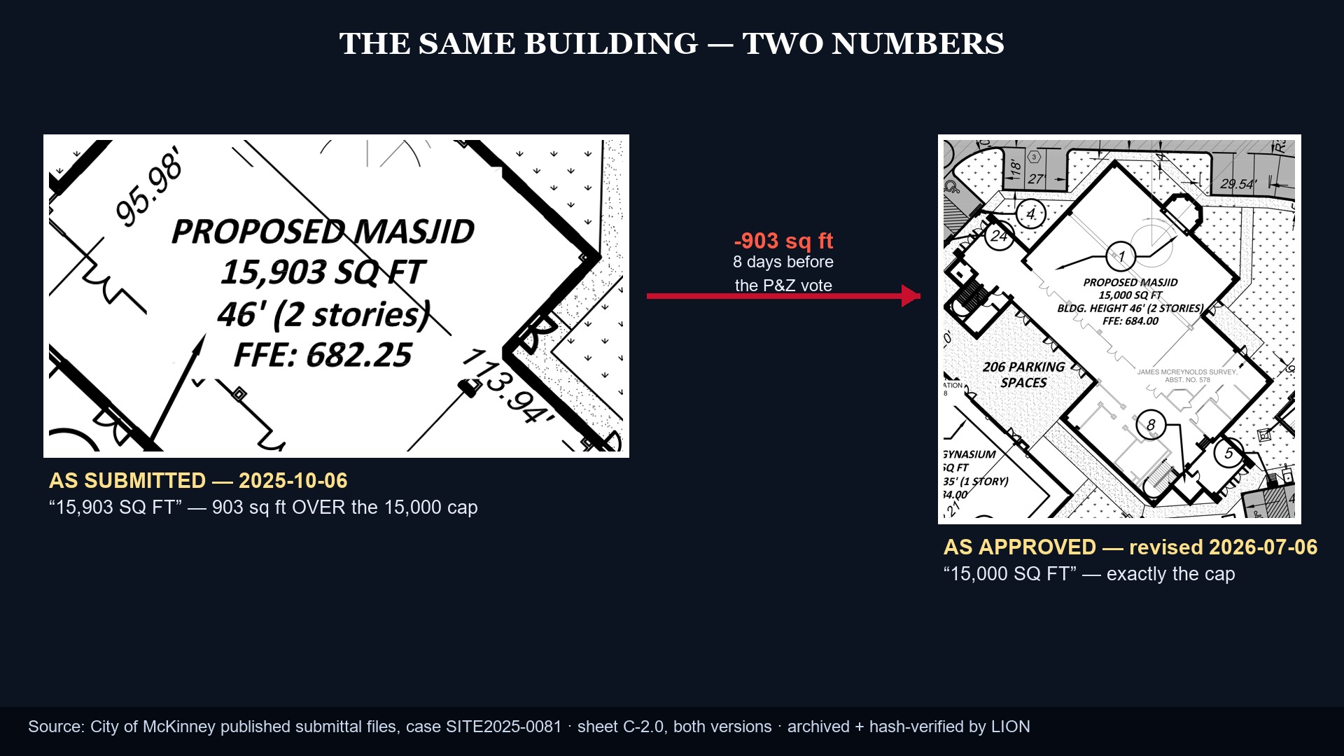
own submittal files and found something bigger: the masjid was originally filed at 15,903 sq ft, over the cap,
and the approved plan carries it at exactly 15,000 — the largest building sitting right on the line. That’s issue ① below.
The same building, two numbers. Left: original submittal (2025-10-06), “15,903 SQ FT,” 903 over the cap.
Right: approved plan sheet (dated 2026-04-21), exactly 15,000. Both are the City’s own files, archived and hash-verified:
original ·
approved ·
evidence manifest.
The case at a glance
Applicant / useMcKinney Islamic Association — religious assembly
ZoningPD-O (Office), Ord. 97-05-34 as amended 2017-04-041
Masjid15,000 sf · 46 ft · 2 stories
Classroom bldg10,236 sf · 38 ft · 2 stories
Gymnasium7,337 sf · 35 ft · 1 story
P&Z (recommendation)2026-07-14 · 7–0–0 · consent
City Council (final action)2026-08-04 · consent agenda
2024 rezone (to lift the cap)Recommended denial → withdrawn
The issues — tap any to open
Four issues where the record does not, on its face, show the plan complies — each expandable to the
full detail and the primary sources. Everything that does check out is folded in below, for fairness.
▸ What checks out — the parts of this plan that meet the code on their face
We’re reading the public record in the open.
Two readers already caught an error and made this brief stronger. If you see a number that doesn’t add up, a
sheet that contradicts another, or a rule we’ve read wrong — tell us. We’ll check it, fix it publicly, and credit you.
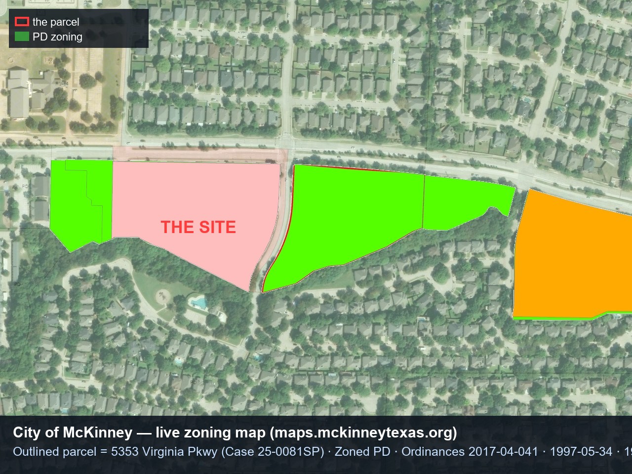
You don’t have to take our word for the zoning. The City’s live map still attaches the 1997 PD to this
exact parcel today — a repealed ordinance would not appear. And here are the two approved sheets the issues above turn on.
The City’s live zoning layer, at this parcel. Returns PD (Planned Development), governed by
Ordinances 2017-04-041, 1997-05-34, and 1997-05-33. (Aerial: Esri. Zoning/parcel: City of McKinney GIS.)
▸ Aug 4 is one gate, not the last — plat, mandatory traffic study, and permits still lie ahead
The Aug 4 Council vote fixes the ground-level layout under the existing PD zoning; it
authorizes no construction. Because the tract is unplatted, several code-required steps remain — and that is where the
traffic study becomes mandatory.
1 · Site plan in progress
P&Z recommendation (7–0–0, 2026-07-14) → Council final action 2026-08-04 (file 25-0081SP2). After Council acts,
under UDC §203F.2 only the applicant or the Director of Planning may appeal (7 days); third parties have no administrative appeal.
2 · Plat (initial) not yet filed
The unplatted tract must be platted before any improvement permit (UDC §301(e)) or utility connection
(Tex. Loc. Gov’t Code §212.012). No plat case appears in the City’s records as of this writing.
3 · Traffic Impact Analysis triggered at the plat
Required for >100 peak-hour trips (Engineering Design Manual §2.13.C) and must be “submitted and approved
prior to the submittal of a final plat” (UDC §305.B.3.c.XVIII).
4 · Construction plans → building permits
Civil plans approved and improvements accepted before the plat records (UDC §302.B); permits trigger
fire-code / occupant-load review and impact fees.
Records requests you can adopt
The internal documents that would settle these questions aren’t public — but you can help pry them
loose. Each request below lives on LION’s Open Records board: adopt one and LION files it with the City as
your authorized agent — at no cost, and without your legal name. Each asks for a single record, so they’re
quick for the City to answer. You can adopt more than one.